| Newsletter - 2015 Archive |
|
Cycling Club |
 |
| Newsletter - 2015 Archive |
|
Cycling Club |
|
Next--->
|
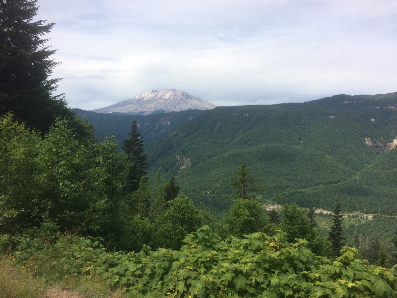
Oh, what a ride...... The Volcano 1000 This ride has been on my mind since my (and others' failed attempt) to complete the Klamath Falls 1000 last summer. The appeal of riding multiple high mountain passes and onto the high dry plateau of central Oregon was a siren call. Careful study of the route revealed that this was to be one very serious, hard ride requiring some thoughtful prep and planning. Seven riders (Bob K., Rick den B., Will D., Bill M. Ed P. Eric F. and I) assembled for the 5AM start at the usual 4th and Boundary location. Paper work completed we headed to the 'Sea to River Bikeway' to climb up to MetroTown and the BC Parkway Bike Trail. No sooner had we turned onto the Parkway, I had Problem # 1 (there were more to follow) a flat.....&*^%^&..... only 7km into the ride. Flatting this early in the ride requires a thorough assessment of the cause, failure to find and correct the cause could result in more problems. Search as I did, I could not find the cause of the flat so I replaced the tire and tube. Twenty minutes later I was on my way with the knowledge that the others were now probably 7 to 8 km ahead of me. I like company when I ride; so do I start the chase; nope, dumb idea to burn myself out at this stage of the ride. I resigned myself to meeting up with them at the designated night stop, 415km away in Morton. Then I had awe, awe moment. The plan was for Rick, Eric and Bob to share the room. I had booked the motel room and made special arrangements to get the room key after normal hours and I hadn't shared the information with the others. They just might hold up somewhat so I could lead them to the accommodation. I arrived at the border in good time, to find Eric standing in a long stationary line. He had stopped for a 'bio-break' as the other carried on. He had been in the line for close to 20 minutes. Only one Border agent was processing travelers. I joined Eric, it was another 10-15 when the 8AM staff shift arrived and additional booths were finally opened up. Off we went together, through Bellingham, along Chuckanut Dr., through Burlington, onto Hwy # 9 and then onto the Centennial Trail south to Snohomish. Eric had never ridden this 40km trail that parallels Hwy # 9 before, he was impressed. Approximately 10km north of Snohomish, to our delight we found the other riders stopped, at a trailside washroom and watering hole (H2O). We were now a group of six. Ed was long gone (I remembered I had given him info about the motel). For the most part the next 170km to Eatonville followed the Cascade 1200 route; mostly quiet back roads, with no hills of any significance except for the 3km climb up to Eatonville. The identified CONTROL location had long since closed. There was a bar/restaurant across the street so in we went. We all wondered as to Will's whereabouts and situation. No one was overly concerned; Will rides to his own plan and tune. The plan was to get in and out of the bar ASAP, but the offer of huge portions of pies was too much...... 30+ minutes later we were on our way to Morton. We were barely out of town when Bill peeled off for a night of bush camping. The 45km to Morton had some steady climbing, the first so far along the route. Rick, Eric, Bob and I arrived at Morton at approx.. 1:30 AM. Ed was sound asleep on the floor; we showered, assigned beds and set our alarms for 5AM. When the four of us left, Ed was still sound asleep on the floor. The next stop was Randle where we provisioned up for the first of the BIG climbs... ELK Pass. This was to be my third time over this beast in less than one year, you'd think I'd have learned my lesson; it was to be the first ascent for all the others. Eric, Rick and I more or less climbed together with Bob not far behind. As we approached the summit Ed reeled us in. The descent to the Northwood Market (just before the big Curly Creek /Old Man Pass climb) as a welcome respite. The market made for a timely lunch stop. Fed and rested we had to get moving, it was now early afternoon and it was getting hot. Not so fast: problem # 2. My Garmin 800 had stopped as it is programmed to do so during periods of no movement, but all my efforts to get it to restart failed. Most of the time the info on the Garmin is more like entertainment ( HR, cadence, speed) to me than info that I consider particularly useful. The route information to the Inn in Government Camp would have been helpful ( but not much) and navigating the final few kilometres into Eugene it might have been a huge help ( more on this later). So I took off the HR monitor and the Garmin 800 head and throw them in my handle bar bag). The Curly Creek climb is approx.. 8km with grades consistently in the 10% + range, and it was HOT!!!!! At the finish the conscious was this was by far the toughest climb on the route. The switch backed laced descent put a smile back on our faces. Two big climbs were done, one to go this day. Stevenson (on the Columbia R.) was a convenient place to enjoy an early dinner stop. To our surprise we met up with Ed, who we consider to be long gone. We crossed the 'Bridge of the Gods' and headed for Hood River. Bob in his wisdom, to route us off a busy section of freeway, directed us onto the Herman Creek Rd. Another surprise. As I rounded a curve there was Ed, just ahead of me, walking! Oh My! What the heck was Bob thinking? With my 28/36 gearing I was determined to ride over this hill and did (@ 4.5kph). We could all have skinned Bob alive at this point. On leaving Hood River the climbing begins immediately and continued for approximately 5km, to be followed by a descent into a deep valley with Mt. Hood rising up on the far side. As we sped down the hill a vehicle pulled onto the shoulder, directly into Rick's path, what the ^&%^&%)^ was the driver thinking. Rick swerved around him as did Eric. To my surprise the passenger door flings open and out steps Bob. He quickly explains that his rear wheel has collapsed and he is finished. He leaps back in the vehicle, they roar off and the driver again swerves onto the shoulder, this time in front of Eric. We learn that the driver offered to take Bob all the way to Government Camp, the next control and overnight stop. The climb up the flank of Mt. hood was relentless. It was now dark, with the better part of 15000' of climbing in our legs for the day we were getting tired and it was getting colder by the minute and with every foot we climbed. This was getting ugly! The summit, but where is Government Camp. It turns out it was a considerable way down from the summit. The downhill speed upped the wind chill considerably, more ugly!!! What a relief when we found the Huckleberry Inn. Sorting out storage for the bikes was at first problematic as we were assigned a room in the loft, eventually the bikes were put in the ski storage room with a gazillion sets of kids skis. There was a ski camp on. Oh, we hadn't seen either Will or Bill all day. At 4AM I awoke to Rick's voice, hum, had he taken to talking in his sleep. I got up, peering down from the upper loft I could see that a fourth rider was now sleeping in an alcove below. Who? Day 3 we were up at 5:30AM including the late arrival, Bill, as were dozens of kids. How Bill found us and gained access to the room remains a mystery, The Inn has a 24hr restaurant so we had a huge, hearty breakfast with the fastest service I've ever seen. It was a beautiful, clear morning..... COLD. Although we were anticipating a long descent to the central Oregon plateau below us, it had to wait as Government Camp was in a hole that we had to climb out of to enjoy that big descent from the alpine, through the tree line to the semi desert plains below. On the plateau it was kilometer after kilometer of flattish straight road, until we dropped into a deep river canyon and the First Nations community of Warm Springs. A rest and refreshments were in order, followed by a long climb back up to the plateau and the long pull to Madras. It was now really HOT!!!!! Thankfully the McDonald's was air conditioned and the pop machine dispensed an endless supply of ice cubes. While enjoying the coolness, Ed blasted by. The 80km stretch from Madras to Sisters was mostly on very quiet back roads, so quiet that Bill with only 1 hrs. sleep was falling asleep on the bike. I wasn't exactly in top form either so I suggested we stop for a 20 minute nap which we did. I find power naps can recharge me for up to 5hrs, so once I was up I was roaring to go. Oh, oh... problem # 3. As I lifted up my bike the bracket holding my handlebar bag onto the bike snapped off and the bag fell off the bike, now what? The rear rake box I was using has fold down panniers sleeves, which I was not using. So all the contents in the box were moved into the pannier sleeves and I was able to cram the front bar bag into the rear rack box. Problem solved with one small issue. My map/route sleeve was built into the top of the bar bag. I could not easily access my route sheet and the Garmin 800 remember had packed it in. No worries. I had the route memorized until we got to the Eugene city limits. On the move again Bill and I put a 7.5km stretch of gravel behind us and rode into Sisters where it was agreed Rick and Eric were to wait for us at a local bike store. This was planned stop for Rick as Sisters is a 'quilting' centre of some renown and he has clear instructions to purchase some fabrics at a specialty store. I was wondering why he had that large pannier with him. One big climb, McKenzie Pass, and the ride was done. Fuel up time again. With the high temperatures (upper 30s) we were all complaining of 'hot foot' (which actually has little to do with the ambient temperature), but I was experiencing I much more troublesome issue, my knees were starting to scream at me, inspite of mega dosing on Tylenol. When the climbing up the pass started in earnest I just had to back off, and told the others to go on. My plan was to ride for as long as I could (tolerate the pain) then walk for 3-5 minutes and repeat as often as required. I repeated this strategy twice when to my surprise I caught up to Bill who was once again in a state of semi-sleep. Then we had one of those moments where one bolts to alertness, it was the scenery, the road was snaking its way through a lava field.... Absolutely awesome!!! Within minutes we were at the summit of the Pass at over 5300' where Rick and Eric were stopped equally in awe at the sight, lava and the three volcanos surrounding us. OK, where did Bill go? Ah, found him fast asleep jammed in amongst large lava boulders. We knew the descent to the Willamette River Valley was going to be amazing, and it was. The first 3000+'' down was an endless series of switchbacks on a silky smooth road. What a rush and we didn't see a single car going down. We didn't overtake any and there was no way a car going down could negotiate those 180 degree turns as fast as we could. Whoopee!!!!!! What we did see was a bobcat. I was descending about 50m behind Rick when bobcat stepped out onto the roadin front of Rick. When it saw us it bolted down the road for about 150m before leaping into the woods. When I went by it, is was sitting on a rock watching us go by.... cool. Although this was the highest pass on the ride the actual climb from Sisters was only 2500', making it one of the lowest vertical climbs on the ride (Old Man was approximately 1500'). The 80kms after the pass to Springfield, a suburb of Eugene, accounted for the remaining elevation loss (approximately 1800'). To say this was boring was to give it more credit than is due. The final 5km into Eugene followed a series of bike paths. What transpired was one of the more hilarious slights I've seen on a brevet. Remember I didn't have easy access to my route sheet so I was relying on the others to lead me in. Eric claimed to have ridden into Eugene on these paths once before and had memorized the route sheet. Neither his recollection nor memory were as sharp as the situation demanded. Rick was judiciously attempting to follow the route sheet queues, and Bill had his head down, focusing on his GPS. The problem was we were deep in a thick forested park with multiple crisscrossing trails looking for a bridge that we could not see. I stopped. All I could see were bike lights moving all around me, going in different directions, frequently changing direction, with frequent calls of, "This way!", only to hear, "No!". It was absolutely hilarious to see, I started to laugh and couldn't stop until I heard a call, "I see the bridge!". Once across the bridge the route through the university paths was equally as convoluted; Bill still with his head down turning right/left. What a hoot. 1 AM (68:04) off to bed we went. Bill got up 4ish (I think) to catch a train home. Ed hoped to catch a train (take the bus) that afternoon. We went to the train station to sort out our travel plans and to pack up our bikes. We had to box the bikes as we had to bus to Portland where we would take the Cascade train to Vancouver. Rick, Eric and I had decided to stay in Eugene an extra day to look about. While boxing the bikes who should appear... Will. We had not seen him since the first day long before Eatonville. Sadly he had run out of time 40km short of the finish. That evening we enjoyed good food and beer, the best way to finish a ride. On the way home we had a four hour layover in Portland. More food and beer. On paper this route really did frighten me. In reality it was not as punishing as I thought it would be; that said it was a very tough, challenging route. The change of scenery, the spectacular mountain views, the ride through the lava field, the great descents make this a wonderful route. Good job putting it together Bob.
Go to: Event Page (Route, etc.) Go to: Results Go to: Photos July 2, 2015 |