| Newsletter - 2008 Archive |
|
Cycling Club |
 |
| Newsletter - 2008 Archive |
|
Cycling Club |
|
Next--->
|
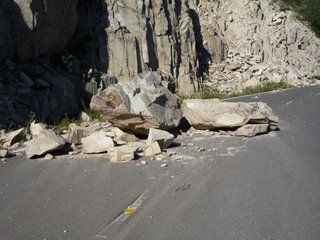
A helluva bike ride It seemed like a good idea at the time... I had failed on the Cascade 1200 earlier in the year, mostly due to extreme heat, but also due to not climbing well enough to arrive at each day's destination with enough time in the bank to get a reasonable sleep. So I decided that I had better concentrate more on doing rides that featured significant climbs. Imagine my utter delight then when I noticed that the Seattle Randonneurs were offering a season ending 600 billed as a "return to the mountains" that would offer a serious challenge even to their most climbing crazed constituents. Four major climbs and a stunningly good weather forecast. What more could I ask for? Well, a sensible starting time for one thing. The final kicker that convinced me to go for it was that they were starting the ride at the completely reasonable time of 4 am. Even if I took the full 40 hours to complete the ride I would still finish by 8 pm on Sunday evening and have a good chance of driving back to Vancouver and getting a decent sleep. The ride started under starry skies and rolled along quite nicely for the first 30 km until the road turned upwards. Gentle at first, then increasingly steep as the night gave way to a glorious sunrise on Mt. Rainier. This was a very scenic climb, but somewhat longer than I am used to in BC at 1350 meters of elevation gain. Still, it went fairly well and I arrived at the Paradise visitor centre at 8:30 am. By this time I was firmly entrenched at the back of the pack. After hunting around fruitlessly for the information control which consisted of some stickers placed somewhere that I couldn't remember, I went and got my card signed at the very posh Paradise Inn. Then followed a truly incredible descent down through the meadows, into the small trees, and eventually into some very big trees before depositing me out into the valley and into the town of Packwood and the second control point. 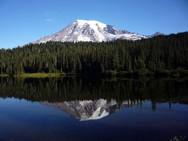 Mt. Rainier on the descent from Paradise (All photos: Bob Koen) A quick refueling and some pleasant and mostly flat terrain landed me at the third control point in Randle. The pre-ride information speech warned us to seriously stock up here due to non-existent resources for the next 100 km or so. There would supposedly be a SIR manned control with water and some food at the top of the next climb. I didn't want to rely on that though since riding at the tail end of the pack can make it a dodgy proposition as to whether there would be anything left by the time I arrived. So I fueled up again and loaded as much water as I could carry aboard my trusty steed and set off. Flat terrain interrupted briefly by a notable little climb brought me to the beginning of the next major climb up to Windy Ridge. Here I encountered something I have never seen before- A paved logging road. This is a concept that we haven't begun to explore in BC, but would be well worth looking into. After finishing with the logging they don't dig impassable ditches across the roads and then leave the roads to the alders. Apparently they do ignore many of them, but some they pave and open them up to the recreationists (hunters, hikers, and climbers). Such was the case with this road. It offered a reasonably straightforward 1000 m climb into the alpine until I arrived at a washout where the road was closed. It was possible to bypass the washout with a bicycle and climb a short but severe grade to a high point where I was presented with a unique view, a treeless but unlogged valley spread out before me. This was the edge of the blast zone from Mt. St. Helens. My front tire decided to have its own little eruption at this point. While standing over my bike taking a picture my front tire exploded. It blew itself off the rim and shredded the sidewall. That's the second Ultra Gatorskin that has done that this summer. It's also the last Continental tire that I will buy. 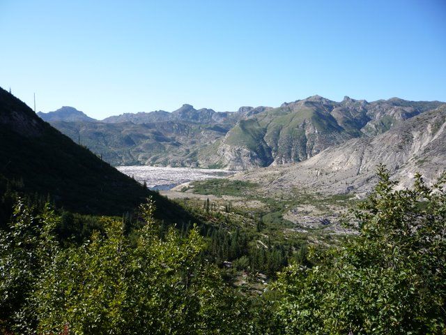 Mt. St. Helens blast zone... Logging without the loggers There was a remarkably clear demarcation line across the valley where trees stood on one side and were blown down on the other. From here on the ride became increasingly surreal. There were no more mature trees except in small areas that had been protected by the terrain from the blast. The area had greened up though with small trees and bush in this outer area of the blast where less ash had fallen. Much up and down on some severe grades led to a junction with a more substantial road. Near this junction I ran into Jan Heine, one of the two organizers. I was just about out of water by this point and was hoping to get some more here. Jan doled out my ration of water which amounted to about 1 gulp and told me to carry on. So I carried on over rolling terrain for the next 12 km on an excellent road that was devoid of traffic. This road carried me into increasingly devastated terrain as I got closer to the crater of Mt. St. Helens. It also became increasingly apparent that the road was closed to vehicles as I passed washouts and rockfall on the road that cars could not get around. I finally arrived at a viewpoint at the end of the road. Here there was an incredible view into the crater and an equally incredible view down into Spirit Lake, which was full of trees that had been blown down and swept into the lake by the eruption. 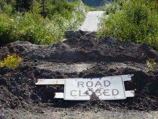
 The ride was conducted on mostly good roads. I quickly turned around and headed back to the junction where Jan was waiting. This was a control point and this time Jan was much more forthcoming with the refreshments. He had bicycled up the paved logging road towing a trailer loaded with 80 pounds of water and food earlier in the morning and was understandably careful with what he was handing out when I had gone by earlier. But by now he was completely clear about the status of his stock as there were only 2 people behind me. He had plenty of water and food now and was urging me and the others still there to eat, drink and be quick about getting out of there. So I did. 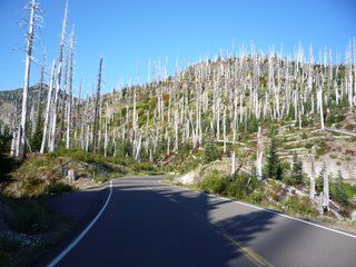 Ghost forest. Next came another surreal stretch of road where the trees had been killed but not blown down, resulting in a ghost forest of standing dead trees. Here I encountered three truly hard core bicyclists towing trailers loaded with (according to their estimates, but I believe them) 130 to 140 pounds of gear. These were hunters who had gone into the area to blast away at some animals for the weekend. Fortunately, the animals won this encounter and they were coming out empty handed. It gave me an idea for a new variation on our sport. Huntoneurring. Or perhaps we could call it Randoblasting. Ride long distances and shoot things. Sort of like the biathlon of the bicycling world. No extra time given for going off hunting in the middle of a ride (after all, Ken Bonner never got extra time awarded for running a marathon in the middle of a 600 Km ride). But perhaps we could give bonus miles for completing a ride with a dead moose strapped to your Caradice bag. On second thought, forget that idea. I soon arrived at the barrier where the road was closed to automobiles and then commenced a long descent to a junction with a more well trafficked, but still fairly narrow road. There were a lot more cars here, but the road was in fairly decrepit condition. While dodging potholes on one stretch I heard a car approaching from behind. I immediately pulled over to the right but then heard a screech of brakes and the sound of a car hitting the gravel shoulder. It turned out to be a carload of drunken teenagers that had intended to pass me on the right. They scared the bejeesus out of me. I finally arrived back in the lowlands in one piece and carried on up through a very peaceful valley under the rising full moon to Packwood and the start of the third major climb of the day. A quick refuel while I put on the full night riding regalia and then I headed out. This was a climb that I was familiar with from the Cascade 1200. I knew that it was another 1000 meters to White Pass on reasonable grades over the next 40 km or so, followed by a long cold descent into the overnight stop at Naches. Unlike on the Cascade 1200 though I started this climb in the cooler part of the evening after a long but not unreasonably hot day. I got a second wind here and actually passed a couple of other riders that had dropped me on the first climb up to Paradise. I finally arrived at Naches at 3:30 am after 23.5 hours on the road with 5200 meters of climbing over 393 kilometers. This had been a long day on the bike. Too long in fact, as I could now only afford 1.5 hours of sleep. This was where the Seattle Randonneurs take a different, but welcome, approach to such rides than the BC Randonneurs. The ride fee is much higher, but they provide a dinner and a bed as part of the fee. I find it difficult to appreciate dinner at 3:30 am (it was excellent food) but the bed was certainly welcome. The 5:30 am wake up call came much too soon and it was back on the road again for the last major climb of the trip. This one was exceedingly gradual for the first 70 km and was familiar from the Cascade 1200. The next 14 km up to Chinook pass grabbed my attention though and it was well past noon when I finished this 1100 meter climb. Remarkable views of Mt. Ranier awaited, along with a white knuckle descent amidst heavy traffic down to the town of Greenwater. By this time I had formed a riding partnership with Mark Thomas and we rode sweep for the rest of the ride. Mark also provided expert technical assistance when I needed to true my rear wheel after the first broken spoke episode of my rando career. 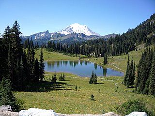 The final reward Mt. Rainier from Chinook Pass. We had lunch in Greenwater and then consulted our route sheets to discover that there was a bonus of nearly 13 km tacked on to the end of the ride. Some quick mental calculations revealed that we were screwed if we didn't make good time on this stretch. Making good time was at first difficult to do because the road was closed due to a motorcycle accident. We rode past several miles of stalled and frustrated motorists until we came clear of the accident site. By this time the road had been opened with one lane alternating traffic and we got through OK. Not before being seriously slowed down though by all the stalled vehicles with all doors open to let air in, including doors open blocking the shoulder that we were driving on. We also got held up by motorists unloading used Budweiser into the ditch beside their stalled vehicles. Eventually we left the main road that we had been traveling on and entered into the home stretch. Here we encountered what I am beginning to understand is a hallmark of Seattle Randonneur rides. It seems that after trying to up the attrition rate through a whole lotta climbing they then try to polish off the survivors by confusing them with intricate route finding to the finish. It would have worked in my case but for my forming a riding partnership with a local. Mark knew all the roads very well and we skillfully turned left when the route sheet said right and also made the turns that weren't on the route sheet at all and arrived at the final control with still a hope of finishing the ride in the allotted time. Note: The last part may be a complete fabrication. The truth is that I completely gave up on trying to navigate through this stretch and just relied on my local guide. Anytime I tried to figure out where we were from the route sheet I got completely confused though and had a few discussions with Mark where I though we should go one way and he said no. He was alwaysright. We picked up another straggler in this stretch, Rick Blacker from Oregon, who had been well ahead of us but got brought to a complete halt for 45 minutes by the motorcycle accident. We then rode together from the last control to the finish and completed the route in a new record slow time for me of 39:05. Not bad I think considering the 613 km covered with a total elevation gain of over 7000 meters or 23000 feet.
Go to: Results (external link) September 23, 2008 |