|
How Far Did They
Ride?
You Gotta
be Kiddin
by Brian List
(Click photos
to enlarge)
As we were driving up I-5 toward the starting
point of the Peace Arch 1000 in White Rock BC I commented, "This
is really a long drive and it's only half as far as we're gonna
ride". Neither Amy Pieper nor Peter McKay responded to my
comment. "Oh, I get it" I thought, " It's not
appropriate to talk about how far we're gonna ride". The
more I think about it I realize it's probably not a good idea
to let yourself comprehend the amount of riding you are about
to do when you are riding such distances. It's best just to focus
on the distance to the next stop.
The next morning we were up at 5:00am.
We loaded up our bikes and started peddling toward the start,
which was Canadian Customs. There was a line of cars already,
at the border crossing. We got in line, the customs official
asked for our passports, then asked how long we were planning
on staying in Canada. "Ten minutes or so" we said.
We explained that we were in a timed event which would go from
White Rock down to St. Helens, OR and back. He shook his head
and told us to move along.
We decided to get our control cards signed
at the customs office and headed in that direction. Karen Smith
from Vancouver BC was waiting for us there. She had her bike
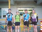 all loaded up and was ready
to ride with us. We would be an international team of sorts.
Very apropos in light of the name of the ride "Peach Arch
- St. Helens - Peace Arch 1000km". We got our control cards
signed and were off to a roaring stop. We now had to go through
US customs. Peter, Amy and I would probably have gotten in the
long line of cars, but luckily for us, Karen has lots of experience
crossing the border on a bike and directed us to the pedestrian
entrance around the back of the building. We explained what we
were doing to another incredulous official and soon were on our
way. all loaded up and was ready
to ride with us. We would be an international team of sorts.
Very apropos in light of the name of the ride "Peach Arch
- St. Helens - Peace Arch 1000km". We got our control cards
signed and were off to a roaring stop. We now had to go through
US customs. Peter, Amy and I would probably have gotten in the
long line of cars, but luckily for us, Karen has lots of experience
crossing the border on a bike and directed us to the pedestrian
entrance around the back of the building. We explained what we
were doing to another incredulous official and soon were on our
way.
We began by bumping our way for ten miles
down an old concrete slab highway called Peace Portal Drive.
I commented, "This is going to feel real good on our buts
after 615 miles". I'm glad I didn't know how accurate my
prediction would be.
We breezed along through Ferndale and Bellingham
and soon were peddling across the Skagit flats. By the time we
reached the first control at the fruit stand on Fir Island, the
day had become completely glorious. The sun was out, the mountains
sparkled in the distance and the temperature was perfect. Of
course, it was only 9am. We could even see Mt. Rainier, a little
white speck on the horizon. I realized that before our ride for
the day was done we would be sleeping in a motel on the other
side of that mountain. I quickly put that thought out of my mind.
We soon had made short work of the climb
over Hwy 534 and were tooling along Hwy 9 when we saw two cyclists
ahead. As we approached, I noticed one of them was wearing a
SIR jersey. It was Mark and Wayne. They had come out to ride
along with us. Spirits were already high but they really lifted
when Mark and Wayne showed up. The miles flew by as we rolled
along telling stories of past disasters and exploits. After about
100k they split off to head up the hill to Redmond while we continued
toward Issaquah.
By this time it was getting very hot, Karen
took a photo of the thermometer she has on her bike when we had
stopped for water in Issaquah, 38° Centigrade, that's 100°
to us metric system challenged folks! We took it easy on the
slight climb out of Issaquah. I was running through my water
like it was water. By the time, we had reached Black Diamond,
only 30k; I had drunk both bottles. We stopped at a ballpark
where I filled my bottles from a hose.
About 6pm, we pulled into the control at
Enumclaw where we had dinner at a Quisno's. We agreed that the
combination of sweat, dirt and sunscreen had us feeling awfully
sticky.
Karen took a humongous pull as we headed
toward our destination for the night. The pace slowed, when I
took over the lead, as we turned onto Orville Road. "No
more bad hills between here and Oregon" I promised. Surprise!
The route turned onto 264th St instead of continuing on Orville
Rd. The grade on 264th is a real leg breaker. "So much for
no more hills" I thought. I deserved the comments I received.
More about 264th St. later.
We stopped in McKenna for more food and
water. I was starving even though we had only gone 60K since
we had dinner. I needed a lump of something that would sit in
my stomach so I wouldn't feel constantly hungry. A ham and Cheese
burrito was just the ticket. Karen found a starving kitty. She
fed him dabs of her energy gel. I felt bad because I had wolfed
down my Burrito before I noticed the kitty.
"It really is flat between here and
Centralia" I announced as we hit the road. I'm not sure
anyone believed me. The final 50k to the control were uneventful.
Amy's husband Robin was waiting for us
at the Motel 6 in Centralia (386k, 241mi) with dinner. He even
put out the SIR control sign so we would know which room was
ours. We made it in at 1am, only one hour behind schedule. Considering
the extra stops we made because of the heat, we were doing great.
I didn't sleep well. I had stomach cramps
and had to get up to use the bathroom repeatedly through the
night. I ate a lighter breakfast than usual but brought along
a PBJ sandwich that I nibbled on as we warmed up during the first
few miles of the day's ride. I felt better and better as the
day went by.
Soon we had reached the major obstacle
of the ride, The Lewis and Clark Bridge. This imposing structure,
which crosses the Columbia River connecting Longview 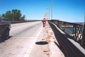 Washington with Rainier Oregon,
combines a long steep climb and heavy traffic with a narrow shoulder
which is never swept. Karen's picture does not do justice to
the amount of crap that is piled up on the narrow shoulder. The
size and volume of the wood chips dropped by the constant barrage
of log trucks is astounding, and there is nothing you can do
except ride straight through it. Mixed in with the chips were
nuts, bolts, a 6" long coil spring, and even piece of rebar.
You'd better have good tires on your bike if you want to tackle
this one! There's nothing for it but to breathe deep, keep a
good grip on your bar, and keep peddling til you're across. Oh,
and don't look down, it's 210' above the river at the high point. Washington with Rainier Oregon,
combines a long steep climb and heavy traffic with a narrow shoulder
which is never swept. Karen's picture does not do justice to
the amount of crap that is piled up on the narrow shoulder. The
size and volume of the wood chips dropped by the constant barrage
of log trucks is astounding, and there is nothing you can do
except ride straight through it. Mixed in with the chips were
nuts, bolts, a 6" long coil spring, and even piece of rebar.
You'd better have good tires on your bike if you want to tackle
this one! There's nothing for it but to breathe deep, keep a
good grip on your bar, and keep peddling til you're across. Oh,
and don't look down, it's 210' above the river at the high point.
The final 30k to the turn around point
in St Helens Oregon (501k 311mi) was uneventful if hot. We sat
in the shade of a convenience store and ate our lunch. We had
made it to the halfway point in 30 hours
(noon Sunday) and we had 45 hours to make it to the finish. It
wasn't in the bag but I for one felt a lot better than I had
when I started out that morning. If only it would cool down!
We had only been at the control for a half-hour or so when we
noticed two bikes flying by. It was Eric and Ken, the other two
crazies that were doing the ride. They had started three hours
behind us and just managed to catch us at the turn around point. the halfway point in 30 hours
(noon Sunday) and we had 45 hours to make it to the finish. It
wasn't in the bag but I for one felt a lot better than I had
when I started out that morning. If only it would cool down!
We had only been at the control for a half-hour or so when we
noticed two bikes flying by. It was Eric and Ken, the other two
crazies that were doing the ride. They had started three hours
behind us and just managed to catch us at the turn around point.
Soon we were returning north, making a
second crossing of the Lewis and Clark Bridge. For some reason
we convinced ourselves that, there would be less crap in the
road on the return leg, wrong! Still it seemed easier the second
time. We stopped for water as we were leaving Longview. It was
getting seriously hot. Karen and Amy needed to stop in Lexington
about 10k up the road from Longview. Peter and I continued slowly.
All of a sudden, I was riding by myself. That didn't feel right
so I stopped and waited for the others. When they came by it
was clear that Peter was having a hard time with the heat. Somewhere
along this stretch, Eric and Ken blew by us like we were going
backward. Peter lay down for a rest just outside of Winlock,
home of the world's largest egg.
Peter left Winlock before the rest of us,
stating we would catch him before long. A few minutes later Amy
Karen and I hit the road. When we got to the next town, Napavine,
I noticed that the route sheet said to turn right when the route
actually went left. I assured Amy and Karen that I knew the way.
We were riding into a stiff crosswind by this point and the going
had gotten tedious. One of the women announced it was time for
a break and I reminded them there was a portapotty at the intersection
of SR603 and Shorey Rd. For those of you who are not cyclists
the issue of, uh… where to go… comes up constantly
on these rides. Finding a Sanican is sorta like "hitting
the jackpot: if you will.
The final 10k or so into Centralia control
was a grind even though it was dead flat. We were tired and hot
and the wind bothered us. We pulled into the convenience store
at the corner of Main and Yew slightly worried. Peter wasn't
there although he had left before us. I tried calling his cel
but only got his voice mail. Amy was absolutely sure this was
where he said to meet him because they had stopped there on a
ride just the weekend before. We decided to get food and wait.
It's probably always a good decision to eat and wait when you
are in doubt. Peter showed up a little while later. He had followed
the route sheet, turning right in Napavine. Luckily, he came
across a friendly policeman who set him on the right path.
We felt confident as we left Centralia
for the final stretch to the overnight Control in Enumclaw, only
70k to go to a nice hot shower and bed. However, the fun was
just about to start. It was dark now as we sped along Hwy 507
between Tenino and Rainier. We started up a slight rise when
we heard a crunching sound from Peter's bike. We went around
a corner and slowed down, no Peter. I decided to go back and
see what was going on, there sat Peter in the ditch fiddling
with his bike. "I'm, ok" he called out, probably knowing
I'd be worried seeing him in the ditch. "Chainring bolts
came out" he calmly stated. "Good thing I have some
spares in my bag, I'd never find them in the dark." "He
carries spare chainring bolts?" I thought. I never would
have thought of bringing spare chainring bolts. Good thing he
did though, that could have been a ride ender. It took Peter
a good half-hour to replace the bolts and tighten them with the
multi tool. I stood over him and shined my light into the traffic
coming around the corner. Amazingly, of the 30 or so cars that
passed only one slowed and asked if we needed help. I mean here's
a guy and an upside down bike in a ditch in the dark. Wouldn't
you want to make sure he was ok? What's this world coming to?
Bike repaired, we rolled along. Soon we
were past Yelm and in what should have been the home stretch.
We just needed to turn onto 264th then Orville Rd. and pretty
soon we'd be there. Just one problem, can't find 264th. We went
from 268th to 260th. We stopped and had a long discussion. This
couldn't be right. We thought that maybe the street designation
changed between where we turned on and off 264th the night before.
I remembered that we went past a school with a flashy sign just
before we turned off 264th. We tentatively headed down 260th.
Hey! There's the school with the flashy sign, must be the right
way after all. We let go of the brakes and bombed down a steep
hill. Whoops, there's a T intersection at the bottom of the hill,
don't remember that. The street sign says 70th Ave NE, Don't
remember that either. "Maybe we just didn't notice the corner
last night" I offered. Peter and I agreed the road to the
right looked more promising. "At least it's in the direction
of the road we want to be on" someone said. We went right
then round a corner and started climbing a steep long hill. The
street sign said we were on Webster Rd none of us remembered
coming down this big hill. We decided to turn around. We stopped
again at the T intersection. Do we go back up 264th?
I don't think anyone actually panicked.
However, things were not looking good, we were not only lost,
we were down in some kinda hole with no way to go but up. We
decided to follow 70th Ave probably because it wasn't as steep
as going the other way. We saw a red light off in the distance.
"Well that has to be something" someone said. As we
got closer, we could see it was a traffic light. The map I'm
looking at now shows it was only about 3k from the T intersection
to the traffic light but it seemed like eight at the time. The
only hint of where we were at the light was a sign declaring
we were in the Graham Fire District. "Where's Graham?"
asked Karen. I started to say something like I actually knew
but thought better of it. Peter flagged down a car. The kids
in the car told us if we took a right and followed 224th we would
come to the Orting Kapowsin Hwy. I remembered from the Daffodil
Ride that would bring us into Orting which in only 3 or 4K off
the course. So off we went and after two fairly big climbs and
one extra knarley decent we eventually got back on course. Once
back on course we checked our computers and noticed that we had
only added about 5k to our distance. Unfortunately, we added
at least an hour and an undetermined amount of stress to the
ride.
The climb up to the Plateau was not to
bad and it wasn't long before we were rolling into the control
in Enumclaw (733k, 456mi). Peter commented, it was a moral victory
that we reached to control before dawn. I think we made it in
around 3am. The shower was wonderful and I slept well.
The first thing we did when we awoke was
look out the window. Yes! Blessed wonderful clouds; thank goodness.
We were on the road around 8am. We had 168 miles to go and 25
hours to do it in. We got wet between Enumclaw and Black Diamond.
We enjoyed the rain, thankful that we would not have to ride
through another day of heat.
A few hours later we passed the 500-mile
mark. That's where I have had to abandon on my two prior attempts
at long brevets. It was too early to begin celebrating, but I
knew I was going to make it this time. The hills on this part
of the course were harder to climb than they were two days before
but no one appeared to be suffering.
Finally, we were over the last big hill and onto the Skagit flats.
Only 90k to go. We started up a small rise when I noticed that
Amy and Peter had stopped. I went back to find out what was happening.
Amy couldn't shift her rear derailleur. Peter fiddled with it
and we took off again. We soon found that Amy was only able to
use her front derailleur, not a problem on the flats but we still
had Chuckanut Drive to go.
Chuckanut Drive in the dark was interesting
and my legs and butt were feeling the long miles but I kept turning
the peddles and soon we were in Bellingham with only 40k to go.
By this time the batteries my headlamp had burned out so I couldn't
read the route sheet. I would have to rely on the others to make
sure we stayed on route.
Somewhere past Bellingham, Amy let us know
we were getting sleepy. We stopped by a little store. It was
closed but well lit. We had something to eat and Amy rested for
a few minutes. Then we took off into the dark. Eventually we
made it through Ferndale and into the home stretch.
Ah, the home stretch, remember Peace Portal
Way? Cachunk, cachunk, cachunk……. 15k of constant cachunking.
We could see the lights of Blaine ahead but the cachunking seemed
to go on forever. I looked over at Amy and asked, "Do you
think we're in hell?" Amy laughed as the road got even bumpier.
I looked up at the sky and yelled, "I didn't mean that!"
I felt like my saddle had been stapled to my butt, however the
end was near.
We pulled up toward Canadian Customs not
remembering whether to get in the line of cars on not. Peter
yelled, "Over here". We coasted around the cars to
the pedestrian entrance and applause from Peter, Karen and her
sister. What a Sister! Meeting us at 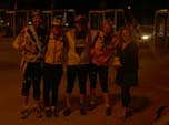 2:40am. She had bread and
peanut butter too, and that was a good thing because where were
no restaurants open at that hour. We stood around in a daze eating
our peanut butter sandwiches and staring off into space. The
emencity of our accomplishment not sinking in. A friendly Border
Guard took our picture. We hugged Karen and her sister and headed
back toward our hotel. At US Customs, we were asked how long
we had been in Canada. About 15 minutes we said. "We took
a little bike ride" we told the official. 2:40am. She had bread and
peanut butter too, and that was a good thing because where were
no restaurants open at that hour. We stood around in a daze eating
our peanut butter sandwiches and staring off into space. The
emencity of our accomplishment not sinking in. A friendly Border
Guard took our picture. We hugged Karen and her sister and headed
back toward our hotel. At US Customs, we were asked how long
we had been in Canada. About 15 minutes we said. "We took
a little bike ride" we told the official.
PS. We got lost the second night because
we turned onto Hwy 7 instead of Hwy 161.
August 7, 2005
Ride Results - More Photos |