| Newsletter - 2004 Archive |
|
|

|
Cycling Club |
|
|
| Newsletter - 2004 Archive |
|
|
|
Cycling Club |
|
|
Next--->
|
Benjamin posted this on the discussion list. It didn't have a title, so we slapped one on. Benjamin's Toil Well, I survived, and have now recovered from this past Saturday/Sunday's 400 km brevet, aka "Toil to the Toll", which went from Lougheed and Boundary to the Coquihalla toll booth and back. The route sheet and first half of the route profile is here: http://www.randonneurs.bc.ca/routes/04_routes/lm_400a.html Weather was quite nice; not much sun, but fairly warm. Highlights include: Beautiful scenic climb up Chilliwack mountain. We were told there would "probably" be a secret control point. Organizers seem to like putting these at the top of a hill in the first third or so of a ride, and sure enough there was Michel Richard at the top, with a big water container. Sit down meal at cheapo diner in Hope. Asked for side of mayo for my fries, was given Miracle Whip or similar. Bleah. Ate it anyway. Old woman on a walker "really liked" my blue hair. Sun had come out at this point, stripped down to shorts and sleeveless jersey in preparation for climb up Coquihalla. Wedged my MEC wool jersey between my GoreTex jacket (strapped to my rackpack) and seat bag. It seemed pretty secure (cue ominous fore-shadowy music). The climb! First up Othello hill, a "Categorie 2" climb. I was not too proud to use the granny gear. A brief, quick descent past turn-off to Othello tunnels, and then the long slog begins. The Coquihalla is actually not that steep, with a similar grade to Burnaby mountain. The main part of the climb is probably similar to biking up to SFU four times in a row, but with much nicer scenery (mountains on both sides, and some good views of the Coquihalla river below to the right). I'm riding with Lindsay Martin, who soon becomes a speck in the distance as we start climbing. I still have to work on getting a little more POWER into these legs. I pass the summit, which is followed by a bit of a descent to the toll booth. Arrgh! I have to climb this again! Finally, the toll booth control point.
It turns out Lindsay has only been waiting a few minutes. I gorge
myself on cookies, donuts, etc., provided by the organizers.
It's a lot cooler up here; we can look down and see patches of
snow still on the ground. Hell and Damnation! My wool jersey
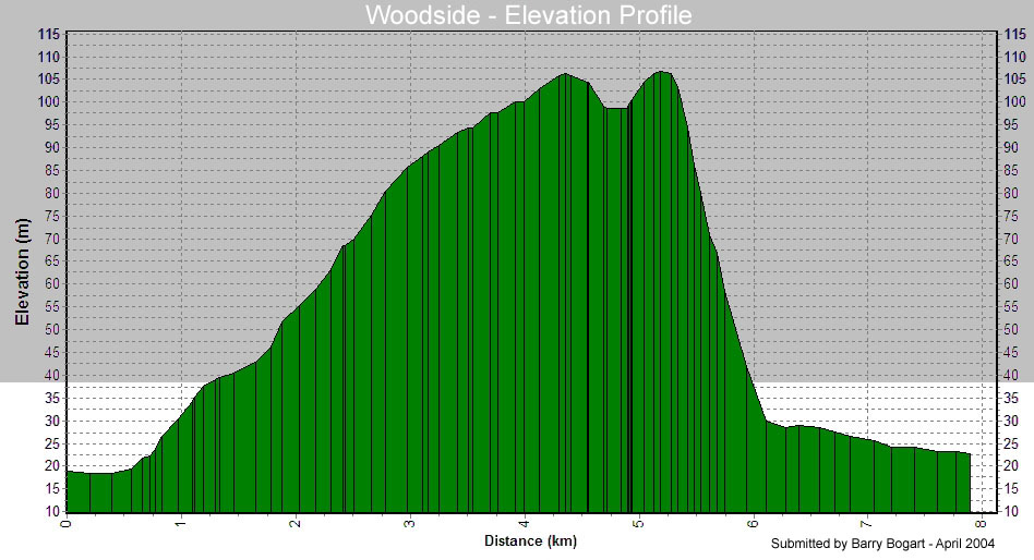
is gone. At $63 it's not terribly expensive for wool, and (Not a "cycling jersey", but functions as one nicely with pockets provided by a short sleeved synthetic jersey over top) Psst -- wool jerseys are really nice. You really want to order one of these (yes, you!): http://www.randonneurs.bc.ca/clothing/wool_1.html Now we get to ride back down! Strong head winds make this a little less exciting; my dream of coasting most of the way back to Hope is shattered. I also can't see over the concrete barrier in the highway median most of the way down, and never find my jersey. Sigh. Almost everyone else is in front of us, so I don't expect to get it back. The wind in my face, combined with a full stomach, produce a strong soporific effect, and I find myself starting to nod off as we descend. Feeling less than safe, I signal to Lindsay and we pull over for a two minute power nap. A nice warm tingly sensation suffuses my whole body. endorphins, perhaps? I am then awake enough to continue, thinking about coffee in Hope. Strangely, the journey back down seems even *longer* than the way up. Feeling more awake at Hope, we decide to press on to the Seabird Island Cafe control. There are some strong head winds coming out of Hope, but we soon get to more sheltered roads, and the wind is probably dying down as evening approaches. Seabird Island Cafe. We run into Claude Theriault polishing off a bowl of Cream of Mushroom soup and mashed potatoes. This looks really good at this point, and we both follow suit. It is dark at this point. The rest of the ride is mostly an uneventful journey back along highway #7. I become drowsy several more times, and Lindsay is kind enough to wait for me as I take 3 or 4 more power naps, probably ranging from 2 to 15 minutes each. Woodside Hill! After cycling 300 km, and approaching from the steeper side, this is not an insignificant climb. Once again, the granny serves me well. http://www.randonneurs.bc.ca/Resources/maps_etc/woodside.jpg We almost miss the turn-off to Mary Hill bypass. Not caring to go back 40 meters, I hop my bike up and over the concrete median. Mary Hill bypass is less than scenic, but is vastly improved by a barn owl gliding along the highway beside us, maybe 5-10 meters away, looking ghostly in the street lights. It lands in the ditch ahead of us, and we get a great view of it head-on as we pass. Knight and Day restaurant: we're finished! It is now 4:44 am, 20 hours and 44 minutes after we started. We sit down with Karen and Michel, and polish off a couple slices of now-cold pizza, nevertheless delicious. We collect our finisher's pins, which are of course the real reason we do these rides. We are now a mere 4 km from my house, so I bike home, quickly rinse off in the shower, and ... BED! Benjamin Lewis _ |